|
Whittier
M.P. F0
Current Population: 263 (as of
2023)
Incorporation Type: 2nd
Class City
Borough Located In: Unorganized
Taxes: Sales: 5%; Property: 8.0 mills; None
City: City of Whittier,
P.O. Box 608, Whittier, AK 99693, Phone 907-472-2337 , Fax 907-472-2404
Whittier is on the northeast shore
of the Kenai Peninsula, at the head of Passage Canal. It is on the west
side of Prince William Sound, 75 miles southeast of Anchorage. The
area encompasses 12 square miles of land and 7 square miles of water. Winter
temperatures range from 17 to 28; summer temperatures average 49 to 63.
Average annual precipitation includes 66 inches of rain and 80 inches of
snowfall.
Be sure to read this great article entitled Pride and progress in Whittier
 The
city originated as a portage route for the Chugach Indians who were traveling
from Prince William Sound to Turnagain Arm to fish. Nearby Whittier
Glacier was named for the American poet John Greenleaf Whittier, and was
first published in 1915 by the U.S. Coast & Geodetic Survey.
By August 8, 1921 Whittier
was becoming a bustling little town. In November 1941, a port and
railroad terminus project was undertaken by the U.S. Army for transport
of fuel and other supplies into Alaska during World War II. On December
7, 1941 the Japanese struck Pearl Harbor. On November 20, 1942, the
"holing through" ceremonies were held on the Whittier-cutoff. The
railroad spur was completed in 1943, and the Whittier Port became the entrance
for troops and dependents of the Alaska Command. The first passenger
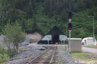
train was run through the Whittier tunnels on March 10, 1943. The
train backed through so guests could observe tunnels from the observation
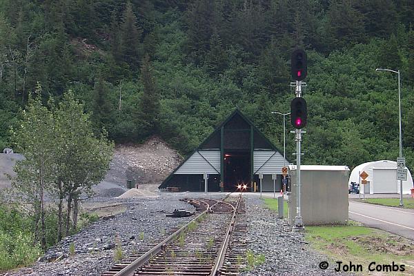
platform. The Portage tunnel is 4,905 feet long and Whittier tunnel
is 14,140 feet. The
city originated as a portage route for the Chugach Indians who were traveling
from Prince William Sound to Turnagain Arm to fish. Nearby Whittier
Glacier was named for the American poet John Greenleaf Whittier, and was
first published in 1915 by the U.S. Coast & Geodetic Survey.
By August 8, 1921 Whittier
was becoming a bustling little town. In November 1941, a port and
railroad terminus project was undertaken by the U.S. Army for transport
of fuel and other supplies into Alaska during World War II. On December
7, 1941 the Japanese struck Pearl Harbor. On November 20, 1942, the
"holing through" ceremonies were held on the Whittier-cutoff. The
railroad spur was completed in 1943, and the Whittier Port became the entrance
for troops and dependents of the Alaska Command. The first passenger
train was run through the Whittier tunnels on March 10, 1943. The
train backed through so guests could observe tunnels from the observation
platform. The Portage tunnel is 4,905 feet long and Whittier tunnel
is 14,140 feet.
The Alaska Railroad's first
diesels numbers 1000 and 1001 arrived at Whittier on June 9, 1944.
They were standard 1000 HP switching locomotives built by the American
Locomotive Company.
Under agreement with the Army, the
Alaska Railroad took over operations at Whittier on December 17, 1945,
replacing soldier forces there. The Army also released 85 enlisted
men for railroad employment as longshoreman.
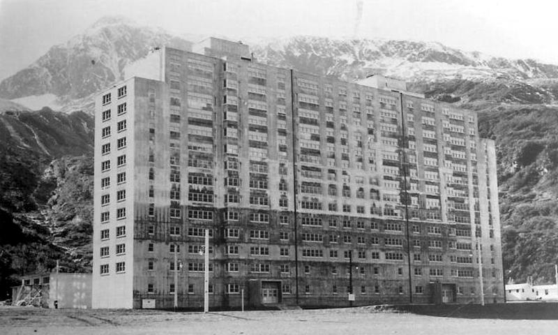
 The
huge buildings that dominate Whittier began construction in 1948. The Hodge
Building (now Begich Towers) was built for Army
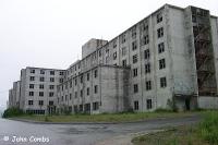
bachelors quarters and family housing. The Buckner Building, completed in
1953, was once the largest building in Alaska, and was called the "city under
one roof." The Port remained an active Army facility until 1960; at that time,
the population was 1,200. During the earthquake of 1964, Whittier, being
the closest city to the epicenter, suffered
incredible damage. The Buckner Building was not repaired
following the earthquake and stands unused. The City was incorporated
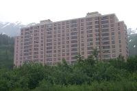
in 1969. The Begich Building is now a condominium, and house nearly all of Whittier's
residents. There's even an underground tunnel from the building to the
school house so the children don't have to go outside during the winter. The
huge buildings that dominate Whittier began construction in 1948. The Hodge
Building (now Begich Towers) was built for Army
bachelors quarters and family housing. The Buckner Building, completed in
1953, was once the largest building in Alaska, and was called the "city under
one roof." The Port remained an active Army facility until 1960; at that time,
the population was 1,200. During the earthquake of 1964, Whittier, being
the closest city to the epicenter, suffered
incredible damage. The Buckner Building was not repaired
following the earthquake and stands unused. The City was incorporated
in 1969. The Begich Building is now a condominium, and house nearly all of Whittier's
residents. There's even an underground tunnel from the building to the
school house so the children don't have to go outside during the winter.
During the April 1990 U.S. Census,
there were 265 total housing units, and 153 of these were vacant. 126 jobs
were estimated to be in the community. The official unemployment rate at
that time was 8%. 37% of all adults were not in the work force. The median
household income was $33,636, and 13% of residents were living below the
poverty level. The main economy of the town is generated by
the small boat harbor mainly from commercial and sport fishing.
 Whittier
is an ice free port and a 70' city dock. A small boat harbor has slips for 360
fishing, recreation and charter vessels. It is served by the state ferry, barges,
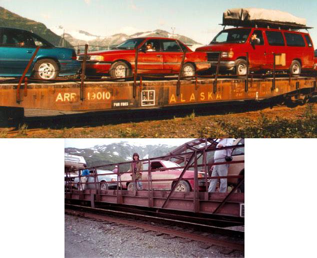
rail, and aircraft. Prior to June 2000, the town was not accessible by
road and the railway carried passengers,
vehicles and cargo 12 miles to the Portage Station, east of Girdwood. Travelers
then drove to Anchorage or Kenai on the Seward Highway. An $80 million
road connection project permitted vehicular traffic to share the 2.5 mile tunnel
with the railroad. Thus, the Whittier shuttle no longer accommodates vehicles
riding on flat cars. Whittier
is an ice free port and a 70' city dock. A small boat harbor has slips for 360
fishing, recreation and charter vessels. It is served by the state ferry, barges,
rail, and aircraft. Prior to June 2000, the town was not accessible by
road and the railway carried passengers,
vehicles and cargo 12 miles to the Portage Station, east of Girdwood. Travelers
then drove to Anchorage or Kenai on the Seward Highway. An $80 million
road connection project permitted vehicular traffic to share the 2.5 mile tunnel
with the railroad. Thus, the Whittier shuttle no longer accommodates vehicles
riding on flat cars.
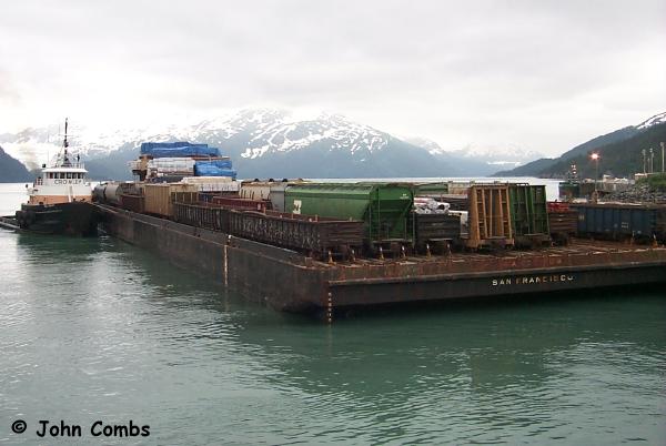
Two railroad related projects are
currently underway in Whittier. As of 2/21/2001 Crowley will no longer
be providing barge services to the Alaska Railroad. In a bidding process
conducted last year the ARRC decided to go with Lynden, Inc., which is
in the process of building three new barges for the service plus a new
barge dock in Whittier. Secondly, the railroad is going to raze its
old warehouse leaving only the section house.
 |
 |
 |
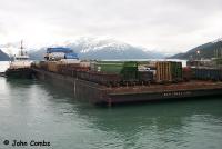
Crowley will no longer bring barges
into the port of Whittier |
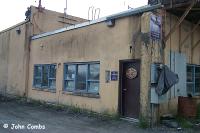
Only this part of the section house will
remain. The left section will be razed. |
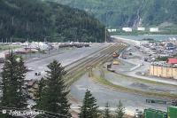
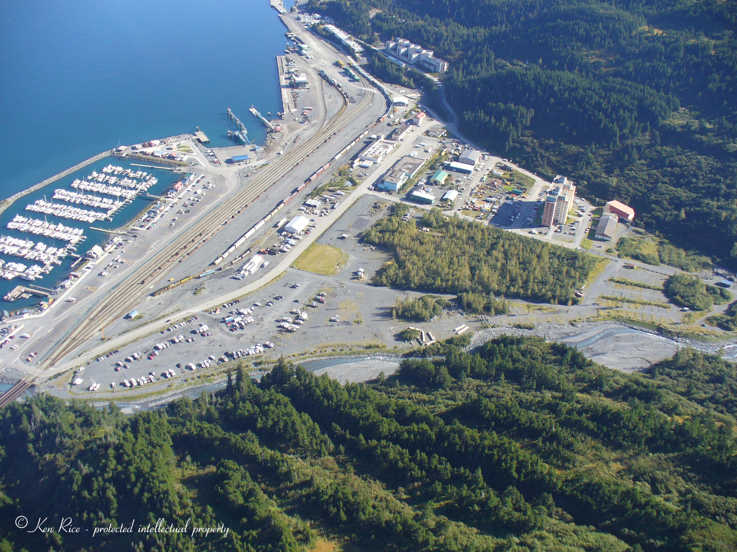
Overhead view of the rail yard as seen from
the Buckner building |
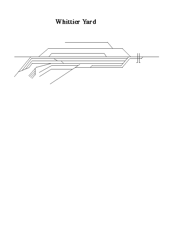
The Alaska Railroad also maintains
a large docking system in Whittier.
Click
here to view the Whittier yard diagram
The Strangest Town in Alaska
Aerial drone video of Whittier
Huna Totem team up with Norwegian Cruise Lines to install a new cruise ship facility
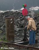
A switch heater keeps ice
from building up in the points
Whittier Aerial Photos
Unauthorized use prohibited
 |
These photos are proprietary. Do NOT use them
for commercial purposes or distribute them |
 |
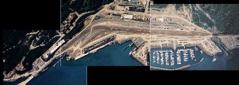
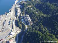
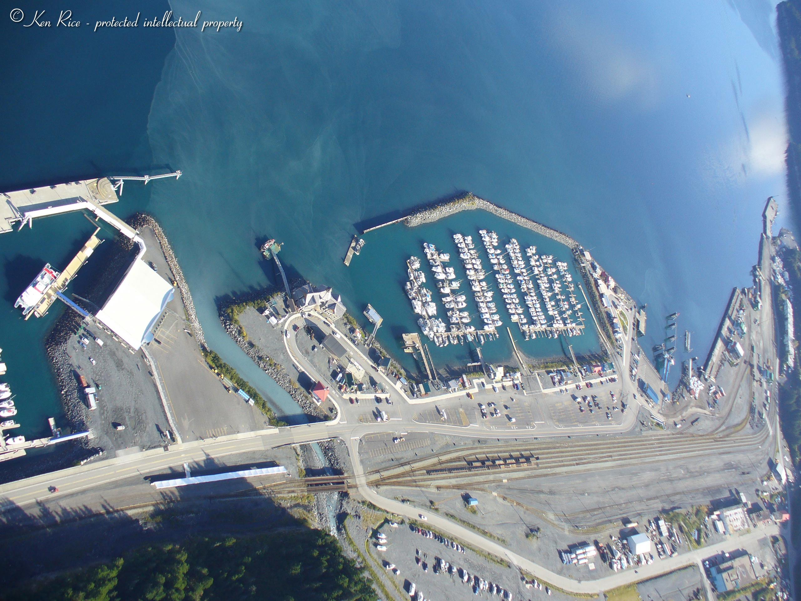
This is the east end of the yard (south if
you're the ARRC). From top to bottom of the view along the water front
are the following features:
- DeLong Dock (ARRC/City)
- Barge Ramp (ARRC)
- Marginal Wharf (ARRC)
- Prince William Sound Cruises and Tours Dock (private - ARRC Lease)
- Alaska Marine Highway System (AMHS) Terminal (State of Alaska)
- Ocean Dock (City)
- Whittier Small Boat Harbor (City) |
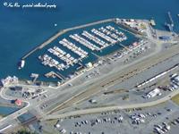 |
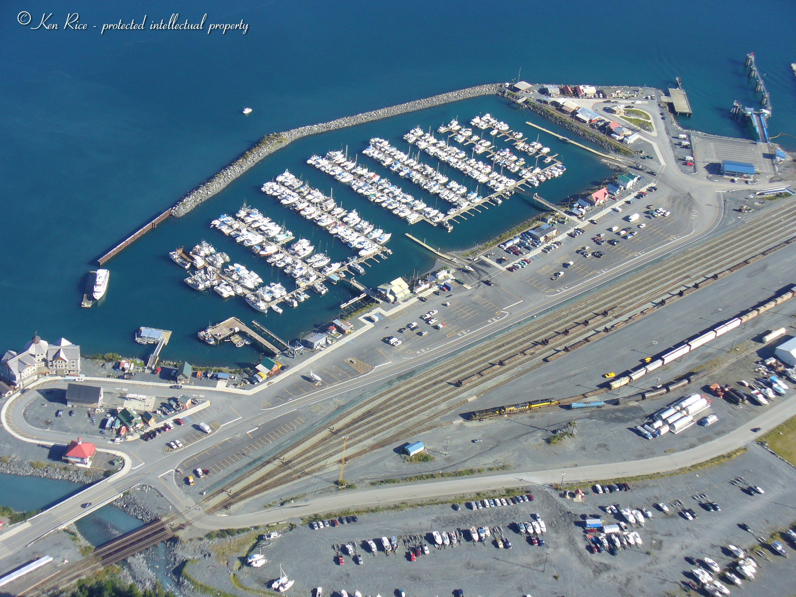
This view is an oblique of the midsection
of the yard, with the City's Small Boat Harbor in the background. From
right to left, the primary waterfront features are:
- AMHS Terminal
- Ocean Dock
- Whittier Small Boat Harbor
Within the small boat harbor are the following features (r to l):
- East Boat Grid (upper right)
- East Boat Ramp
- East Access Trestle and Gangway
- West Boat Ramp
- Whittier Auxiliary Coast Guard (ex-ARR Caboose Number 1076, which
was built by Pacific Car and Foundry of Renton, WA, in 1949)
- Harbor Office
- West Access Trestle and Gangway
- West Boat Grid
- City Dock (with boat travel lift on paved uplands)
- Fuel Dock (leased by City to Shoreside Petroleum, Inc.) Note: Shoreside
Petroleum's Whittier facility marine fuels and petroleum products to
the Prince William Sound fleet. The fuel dock is located in the small
boat harbor. Tank truck deliveries are also available for the large
vessels at the AMHS Ferry Dock and Alaska Railroad Dock.
The rail yard features, from right to left, are as follows:
- Shoreside Petroleum, Inc. fuel storage tanks.
- Three ARR Geeps working the yard.
- F1.2 Bridge—parallel 126-foot open timber trestle bridges that
cross Whittier Creek) and a 3-track grade crossing.
- Seasonal ARR passenger facility. The ARR Glacier Discovery and Princess
Tours charter trains load and offload passengers at this seasonal, tent-like
structure across from the cruise ship terminal and marina. |
 |
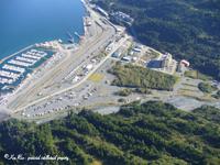
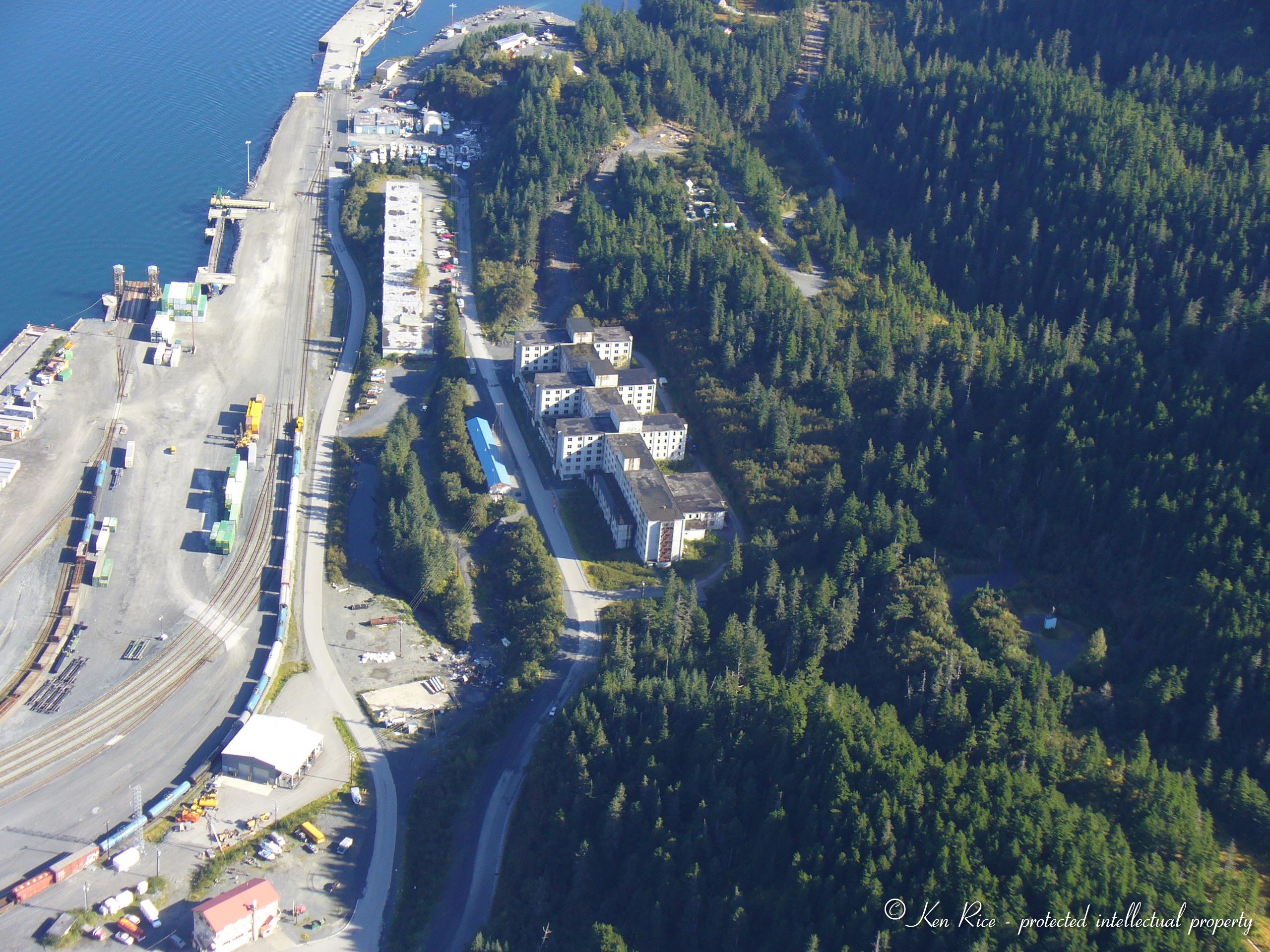
Here is the more detailed view of the ARRC
barge dock. From this view, you can get a better idea regarding container
movements from the port ramp. Again, top to middle-left waterfront features
are:
- DeLong Dock (truncated east end)
- Barge Dock (full view)
- Marginal Wharf (east corner)
The large buildings are:
- Whittier Manor (elongated east-west building - upper left)
- Buckner Building (abandoned multi-story concrete building with window
"holes" - center)
- ARRC Maintenance Shop (blue walls and white roof - lower left by tank
cars)
- Anchor Store (multi-story white walls with red roof - bottom left)
Fun test: find the abandoned ex-army tank car (no trucks). Hint: it's
hidden in plain view. |
 |
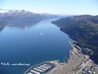
A view to the west (north, if you're the ARRC) from the small boat
harbor to the Anton Anderson Memorial Tunnel. Included in this view
is the Coral Princess docked at the private cruise ship dock. Also included
is F1.2 Bridge—parallel 126-foot open timber trestle bridges that
cross Whittier Creek and a 3-track grade crossing.
Seasonal ARR passenger facility. The ARR Glacier Discovery and Princess
Tours charter trains load and offload passengers at this seasonal, tent-like
structure across from the cruise ship terminal and marina. |
 |
This is probably the best overview of the
main yard layout. It's an oblique, but straight down the primary sidings. |
Back
Page was created 12/1/99 and last updated 7/15/25
|


