Portage
Portage got its name by being on
the portage route from the Gulf of Alaska to Cook Inlet. The 1964
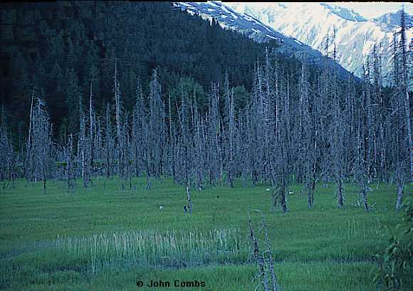
earthquake destroyed the town when the earth subside up to 12 feet.
The ghost forests were
created when the ground sunk and salt water flowed in. The Alaska
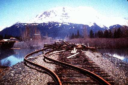
Railroad suffered greatly from this catastrophe. The rails in the
region were torn from
their ties and buckled. In one area, water covered the rails
during high tide. When the water receded, the tracks would be cleared,
and the railroad would resume operations.
At one time the site was a motor vehicle loading area for the Alaska Railroad that carried passengers and vehicles to Whittier for connections to the Alaska Marine Highway. No vehicles can drive directly to Whittier using the tunnel. There is a small visitor information center at the ticket office. Portage Glacier is the major tourist attraction in the area. Portage Creek carries gray silt water from the glacier into Turnagain Arm, creating the mud flats near shore. Visitors should not venture onto the flats due to quicksand and bore tides. Added 12/1/23 Kenai Peninsula History by Jim Taylor: Portage Valley and Portage Pass connects the Kenai Peninsula to the mainland of Alaska with a land mass of only a dozen miles. Today the valley with its hanging glaciers are a draw for locals and tourists to bask in its beauty. But for hundreds of years Portage Pass and Portage Valley performed a different function. This was considered a preferred route for crossing between Cook Inlet and Prince William Sound. It was Alaska natives that discovered and first crossed between Sound and Inlet via Portage Pass. Mikhail Teben'kov in Atlas of the Northwest Coasts of America (published 1852) made this observation: “This isthmus (Portage Pass) consists of a pass between the mountains, covered by ice, under which streams flow, melting during the summer into sheer ice fields. The boldest of the Natives set out across the isthmus in winter, when the icy passes and the channels of the streams are strewn with snowdrifts.” Russians in the quest for fur used this route after their arrival as reported by George Vancouver. “Vancouver described a cross-peninsula trade route near Portage Valley ‘across which isthmus is the route, by which they (the Russians) state that all their intercourse between the Russian settlements, in this and that extensive inlet (Cook Inlet and Prince William Sound), was now carried on.’” After the United States purchased Alaska the route was still being used by early miners heading for Kenai Peninsula mining locations Hope and Sunrise in winter months. Ships were willing to enter the waters of Prince William Sound but shied away from the floating ice cakes of Cook Inlet. Seward historian Mary Barry tells us “Portage Glacier covered about four or five miles of this route. Stakes and ropes marked the trail...very few lives were lost by people who stayed on the path. However, if they strayed off, they risked falling into dangerous crevasses.” The Portage Pass route eventually fell into disuse. The competitor that took its place was the new port of Seward with an expanding railroad and construction of the Sunrise Trail. Early in the beginning of last century it was determined an overland route between the port of Seward and the active mining communities of Hope/Sunrise needed to be established. In 1906 the Alaska Road Commission reported : “This trail is designed to connect the towns of Hope and Sunrise on the Turnagain Arm of Cook Inlet with the Alaska Railroad. Cook Inlet is frozen in winter, and its navigation in summer is not easy.” In 1907 actual construction began and 37 miles of road completed with just over twelve thousand dollars spent. In 1908 The Alaska Road Commission stated: “This road connects mile 34, Alaska Central Railroad, with Sunrise and Hope, two small mining towns on the shore of Cook Inlet. Travel over this road is steadily increasing, and it is expected that 1000 people will have passed over it this season. There is a mail service over the road twice a month during the winter". The road was originally known as the Sunrise Trail. Years went by and things changed as they always do…the gold rush ended, the Seward Highway was built and the Sunrise Trail faded from prominence as a main route across the Peninsula. Today a portion of it is still in use as a trail attracting hikers and backpackers but the shortened version goes by a different name now…the Johnson Pass Trail.
See also:
Page created 12/1/99 and last updated 12/1/23 |
