Progress on Government
Railway in Alaska
Railway Age Gazette
April 20, 1917
Work on the 471 mile railway which the United States Government is building in Alaska has been in progress for two years. The 71 miles of existing railway which the government purchased from the Alaska Northern Railway for $1,150,000 is being rehabilitated and restored to traffic and track has been laid on nearly 73 miles of new line, including 62 miles of the 75 mile connection between the Matanuska coal fields and tide water at Anchorage. In addition clearing and grading has been in progress on about 100 more miles of line, the completion of which during the coming season with a connection with the Alaska Northern will form a continuous main line of some 210 miles in addition to the 38 mile Matanuska branch and work on about 50 miles of the north end of the line. Measured by the present rate of progress the line will be completed between Seward and Fairbanks, the northern terminus in 1920 or 1921. The construction activities have encouraged colonization materially, both in the town sites and on agricultural lands and arrangements are being made for the leasing of the coal lands.
The purpose of this railroad is to connect the navigable streams of interior Alaska with tide water on the Gulf of Alaska, to provide adequate communication with the outside world for the fertile agricultural areas and mine deposits situated in the Yukon basin, which are now isolated for many months of the year because of the closing of the Yukon river to navigation by ice. The completion of the line is also expected to open up agricultural territories and valuable metal and coal deposits along the route which have been undeveloped heretofore because of a lack of transportation.
The route followed by the line now under construction was selected by President Wilson upon the recommendation of the Alaskan Engineering Commission after an extended investigation. As two rail lines built by private capital had already developed two of the best harbors affording entrance into the interior, these studies considered the utilization and incorporation of these lines in the routes investigated.
The Location
The location selected starts at Seward on the Kenai peninsula and utilizes for the first 71 miles, the Alaska Northern railway, built as a private venture between 1904 and 1909. Crossing the Kenai mountains, the line again reaches tide water at the head of Turnagain arm of Cook's inlet, 65 miles from Seward and follows the north shore of this arm in a westerly direction until a turn to the north can be made along the east shore of Knik arm. The line continues within reaching distance of tide water for a distance of 85 miles to Matanuska junction which is 150 miles from Seward. Advantage has been taken of this situation to establish a second port for the railway on the east side of Knik arm known as Anchorage. Although the use of this port permits a saving of 115 miles in rail travel, the through rail communication to Seward is deemed necessary because the latter is an all the year port, whereas Cook's inlet is closed to navigation four or five months of the year. A third port of entry may be secured at any time by the construction of a 12 mile line from the head of Turnagain arm easterly across the narrow isthmus to Passage Canal, an arm of Prince William Sound.
The route of the main line from the head of Knik arm leads to the northwest into the valley of the Susitna river, a stream draining a basin between the Alaska range and the Talkeetna mountains and emptying into Cook's inlet. The location turns northward, following this stream and its tributary, the Chulitna river, to a crossing of the Alaska range at Broad Pass. Descending northward the line follows the course of the Nenana river to its junction with the Tanana in the interior of Alaska. The last named stream is crossed near its junction with the Nenana and the line turns to the northwest to a junction with the Tanana Valley railroad, seven miles from the town of Fairbanks. In addition to this main line, the President's order covered the construction of a 38 mile branch line from Matanuska junction at the head of Knik arm up the Matanuska river to the coal fields at Chickaloon.
The Alaska Northern Railway
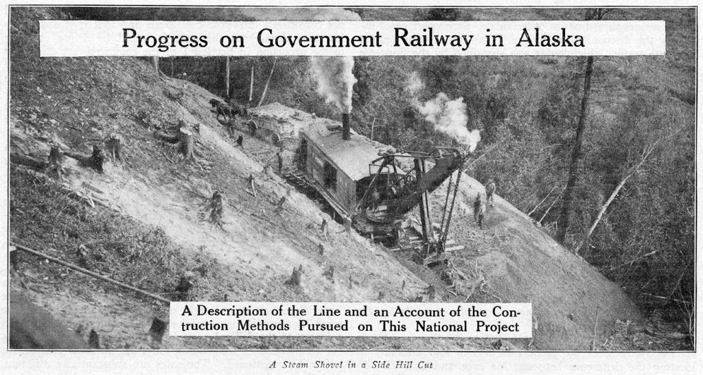
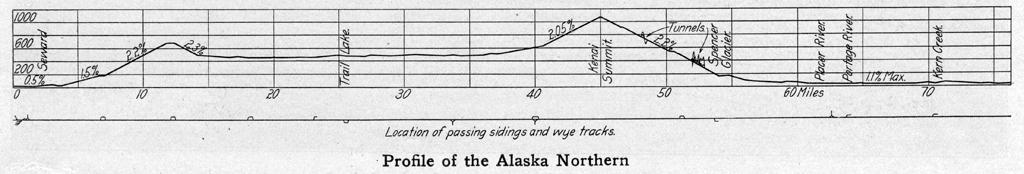
One of the most interesting sections of the entire road is the 65 mile line across the Kenai peninsula, comprising the Alaska Northern railway and involving as it does the solution of some of the most formidable problems encountered in the project. The profile defines two distinct summits. The first is 12 miles from Seward with an elevation of 700 ft. and the second at mile 45 crossing the Kenai mountains at an elevation of nearly 1,100 ft. above sea level. The northbound grade up the first summit is over two per cent and with curves of 10 and 12 deg. uncompensated the grade is equivalent to at least 2.5 per cent. The southbound grade is 2.1 per cent. Between the two summits the country is undulating with easy grades for most of the distance. The south approach to the Kenai summit is on a 2 per cent grade with fairly good alinement but the grade descending northward in the Placer river canyon is on a 2.2 per cent grade in difficult country. Between miles 48 and 51 it was necessary to resort to artificial development in the form of two loops involving high timber trestles, one of which is over 106 ft. high. A number of tunnels were required on this portion of the line and snowslides cause trouble in various places. The improvement of this location is seriously hampered by the presence of two glaciers descending into the canyon from the east side, which make it necessary to avoid that side of the canyon entirely. In consequence any plan for improving the north bound descent involves a line carried on a shelf along the west wall of the canyon which would entail very heavy work including numerous tunnels and snow sheds. This improvement is not contemplated at the present time.
From the foot of the present grade to the head of Turnagain arm, the line is located in flats of the Placer river, crossing numerous glacier streams carrying large quantities of suspended matter, and which are continually shifting their locations over wide areas as deposits of gravel or silt raise the general level of the flats. This is typical of a large number of Alaskan streams and introduces a serious problem in railway location and maintenance. At the point in question the tracks of the Alaska Northern were not elevated sufficiently above the stream beds and long stretches of the line had been washed out at the time that the Government took possession.
Turnagain Arm and Knik Arm
The heaviest work encountered on the portion of the line under construction during the last two years is along the north shore of Turnagain arm where the line is benched in steep transverse slopes, with a moderately undulating grade line not exceeding an elevation of 100 ft. above sea level. The shore line is irregular, making it impossible to follow it even with a curvature up to 10 deg. Consequently the construction consists of side hill cuts with fills across the indentations of the shore line. All cuts over four to six feet in depth are in a hard blocky slate with some quartzite. The bridge work is light. The end of the track on the old Alaska Northern is at Kern creek, six miles northwest of the head of Turnagain arm. Beyond this point the work is entirely new and the estimated cost for the 33 miles along the arm is approximately $77,000 per mile for grading and bridging. This does not include snow sheds which are estimated to cost from $500,000 to $700,000 additional. Very little clearing is required in this section.
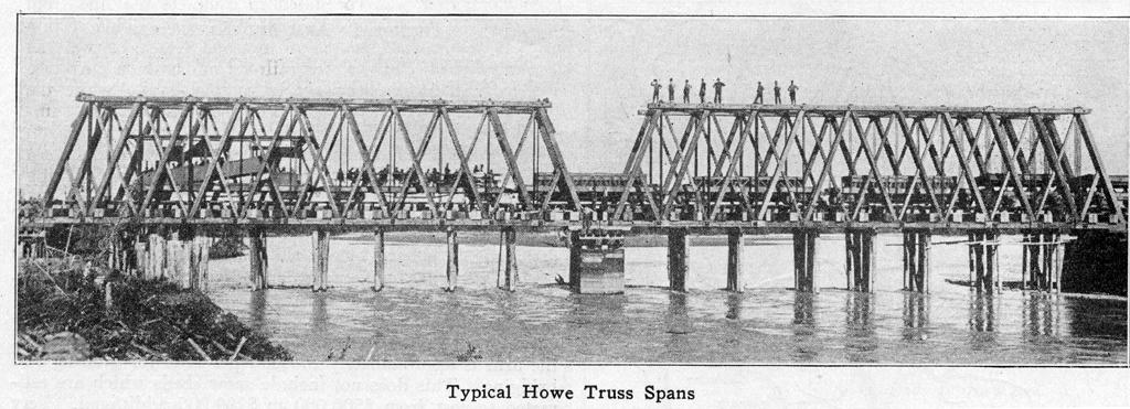
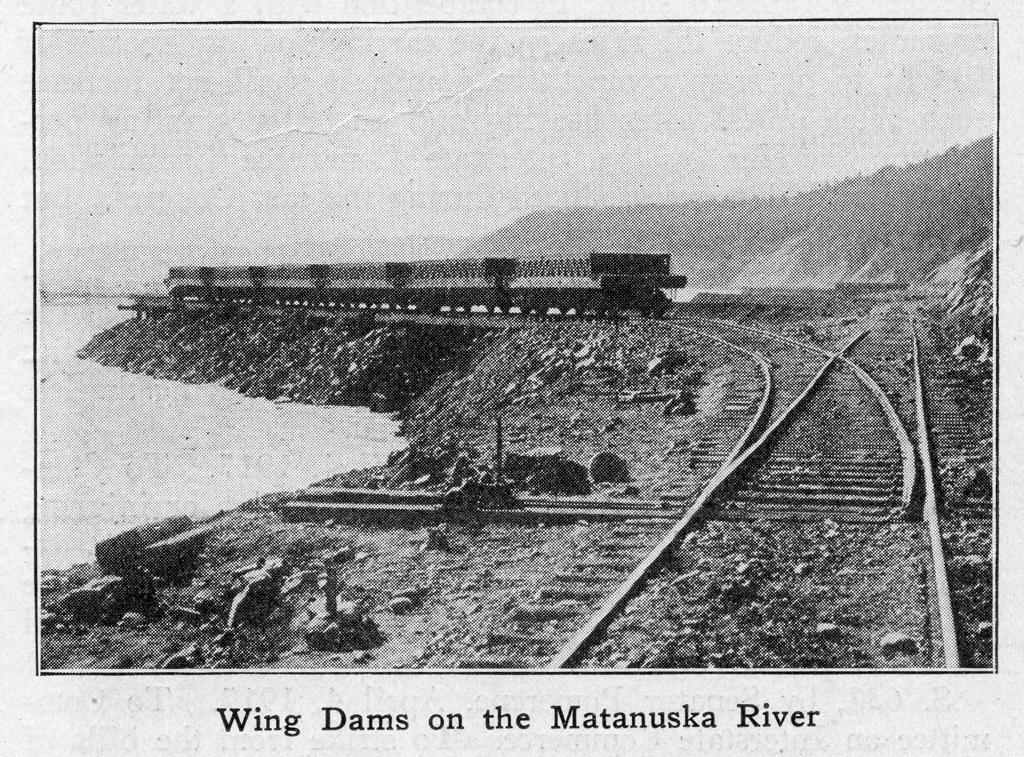
The character of the country along Knik arm is entirely different. Flat rolling slopes covered with a growth of small spruce and birch predominate and it has been possible to supply a large part of the tie requirements from the right of way and adjacent lands. The soil is a gravel covered in many places with moss of a maximum thickness of three feet. Grades and curves are light for the most part and the line is located from three to six miles back from the shore. At the head of Knik arm the line crosses tide flats for a distance of six miles where the Knik and Matanuska rivers enter the bay. The streams are each crossed with three 120-ft. Howe truss spans and considerable stretches of pile trestles. Except for these openings the line is on an embankment for the entire six miles.
The branch to the Matanuska coal fields extends northeast from Matanuska junction to Chickaloon, a distance of 38 1/2 miles. The latter is at an elevation of 983 ft. above sea level and the line is practically on a water grade along the banks of the river for the entire distance. The maximum grade is one per cent east bound and 0.4 per cent west bound (with the traffic). The work may be classed as about 40 per cent heavy and 60 per cent light.
From Knik Arm to Fairbanks
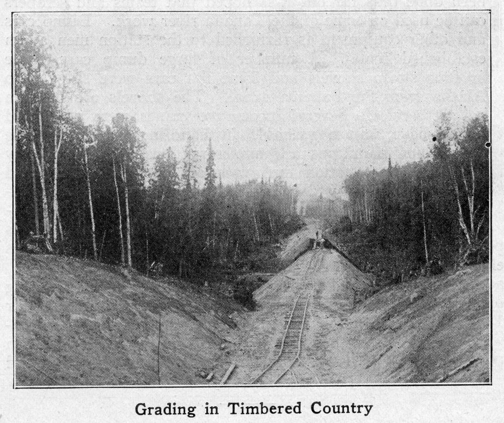
For the first 120 miles northwest from Matanuska junction the country is closely timbered with small spruce that will serve for cross ties, short piling, box culverts, etc. Leaving the head of Knik arm the line makes a climb on a one per cent grade with considerable curvature to about elevation 325 and, holding approximately to this contour, skirts the foot of Bald mountain into the Susitna valley. Here the grade line is undulating but the alinement is generally easy. The grading is relatively light except where the line crosses the numerous streams flowing westward into the Susitna river. Seventy five miles out, the line approaches close to the river which it follows north on virtually a water grade. The work becomes heavier and the alinement more irregular.
One hundred and twenty miles from the tide water where the line, rising with the water grade, has attained an elevation of about 750 ft. it turns up the canyon of Indian river and climbs with a maximum grade of 1.75 per cent about 600 ft. in 11 miles to Chulitna pass, where an elevation of 1,370 ft. is reached.
The line then continues with a maximum grade of 1.75 per cent for a further distance of about 6 miles to an elevation of 1,690 ft. From this point the line descends on a maximum 2.2 per cent compensated grade for a distance of three miles into the Chulitna river valley to elevation 1,380. The river and its tributaries are followed northward with a maximum ascending grade of 1 per cent compensated to Broad pass, a distance of 27 miles. Of this distance about 5 miles is heavy work, the remainder being mostly embankments from three to five feet in height.
Broad Pass, 167 miles from head of Knik arm, is six to eight miles wide, timbered with scattering spruce and much less rugged than the country to the north and south. The maximum elevation reached is a little more than 2,400 ft. and for some distance the grading is relatively light. This is also true for 25 miles north of Broad Pass.
About 24 miles from the pass the line reaches the Nenana river, the general direction of which is then followed for 77 miles to the Tanana river. For 10 miles the line is located through the Nenana canyon, necessitating some quite heavy work and a few short tunnels. The river flows in a deep canyon with a swift current and is a dangerous stream, making railway location and construction difficult. For most of the remaining distance to its junction with the Tanana the country is less difficult, particularly the last 50 miles where the line is located in bottom lands. The Tanana river is to be crossed by a steel bridge of four spans with trestle approaches of considerable length. To allow for the navigation of the river, one of the spans will need to be movable to give a clearance of 60 ft. above high water. This structure is estimated to cost about $650,000. From the Tanana river to Fairbanks, a distance of 57 miles, the line follows a location from 12 to 14 miles northwest of the Tanana river on easy grades with light construction work for most of the distance. Little or no rock is encountered.
Terminals
An important item in the initial work on the road consisted of terminal developments at Seward and Anchorage. At the former the old Alaska Northern dock has been replaced by a new one supported on creosoted piles. At Anchorage, which is the main depot for all new construction, an extensive terminal was established. All transfer from ships is by lighters and at the present time no plans have been made for a permanent dock that will overcome the 35 to 45 ft. tidal variation. The development at this place has resulted in the growth of a city which is said to have a present population of about 5,000 people. Further development at Anchorage and Seward will depend very largely upon the rapidity of the commercial development of the Matanuska coal fields.
Standards
Exclusive of the Alaska Northern the ruling gradient in both directions will be one per cent except for a 1.75 per cent north bound grade and the 2.2 per cent south bound grade in the vicinity of Broad Pass previously mentioned. The maximum curvature is 10 de . on the main line with a limited number of 1 2 deg. curves on the Matanuska coal branch. On the Alaska Northern, reconstruction will reduce existing grades to 2.2 per cent compensated and will reduce the curvature to 10 deg. with the exception of one 14 deg. curve on the loop in the Placer river canyon. Cuts have a base width of 18 to 20 ft. and fills are from 16 to 18 ft. wide on top. The ties are 6 in. by 8 in. by 8 ft. and of native spruce and hemlock. The standard rail is a 70 lb. A. S. C. F. section of open hearth steel. The Alaska Northern was laid with 65 lb. rail with 15 miles of 56 lb. The latter has been replaced by 70 lb. rail and some 65 lb. rail which the Alaska Northern company had received but never laid. Howe truss bridges are being used for openings up to 120 ft. span. This will take care of most of the bridges required but in the south approach to Broad Pass a number of high steel viaducts will be constructed. The bridges are designed for Cooper's E 30 classification.
Construction Progress
The actual construction of the line was started in the spring of 1915 and has continued without interruption to date except for the temporary cessation of such work as cannot be carried on during the winter months. Work has been prosecuted from several points of which the most important are Seward and Anchorage. The Alaska Northern had virtually suspended operation some time before its purchase' by the Government and its physical condition had deteriorated to such an extent that extensive rehabilitation was necessary before operation could be resumed. Because of this and the fact that the work along Turnagain arm is very heavy between the end of the Alaska Northern and the town of Anchorage, it was concluded to complete the line from Anchorage to the Matanuska coal field first. This section promises the earliest source of revenue traffic as well as affording a supply of coal for railroad and marine purposes. This connection has been nearly completed and while the repair of the Alaska Northern has been finished to a sufficient extent to permit of operation of light trains, work on only 15 miles of the 45 miles between Anchorage and Kern creek has been finished, although rapid progress is being made on all of this section of the line.
From the head of Knik arm, grading has been completed for about 25 miles out on the main line. Some work has also been done in the Susitna valley, where supplies could be sent in by boats plying on the Susitna river. Clearing is also in progress between this point and Matanuska junction and during the coming season it is expected to complete the line to Indian river, 156 miles from Anchorage.
On the other end of the line where access can be had via the Yukon, 100 miles of clearing and 7 or 8 miles of grading have been completed. Thirty miles of rail were sent in via St. Michael in 1916.
The transportation of supplies and equipment is the most formidable problem encountered. Work has been prosecuted first on those portions of the line tributary to water transportation. As the crossing over Broad Pass is isolated it will obviously be finished last. Because of the soft road conditions in Summer it is necessary to conduct most of the transportation overland during the Winter when the ground is frozen. In addition to this the Winter activities consist of clearing and rock excavation.
Construction Methods
All grading is done by station men. The ballasting, hauling of material and rail laying is done by men in the direct employ of the commission at an hourly wage rate. The men are principally Russians, Italians and Swedes, the latter working principally on rock excavation. A few Americans are employed but the resident white Alaskans as a rule do not take to the construction work. The eight hour day is in force for all men working at a daily rate.
The station work as carried out has been very successful, a carefully prepared contract having been drawn up to cover the details of the agreement. This is signed by each man of each co partnership engaged in the work and each man receives a separate check for his portion of the payment. The rates on excavation are 75 to 90 cents per cu. yd. for solid rock, 40 to 45 cents for loose rock and 30 to 40 cents for common excavation. For overhaul in excess of 400 ft. 1 1/2 cents per cu. yd. per 100 ft. is paid. In 1915 the average earnings of station men on 41 contracts, after deducting the cost of tools, explosives, team and equipment lure and wages for laborers employed, was 41 cents per hour per man.
Clearing costs $30 to $75 per acre, piling and hewn culvert timbers 10 to 15 cents per foot and ties 35 to 37 cents each. Lumber for bridges and buildings is imported from Puget Sound and costs an average of $18.50 per 1,000 ft. b.m. delivered at Anchorage.
The use of heavy excavating machinery is precluded by the difficulty of transportation. In consequence the equipment used in the grading work has consisted for the most part of dump cars pushed by hand. No team work has been done thus far but it is hoped that teams and scrapers can be used on some of the Tanana river work. Dump cars and other equipment is furnished to the station men at an established rental. A number of large dump cars, three or four steam shovels and some flat cars were shipped to Alaska from the Panama canal. The shovels are used in ballast service. Several locomotive cranes were purchased which have proven valuable in handling material. The commission maintains a commissary department to supply employees and station men with all kinds of living and working supplies which are sold at reasonable rates, although the men are not required to patronize this commissary. At Anchorage an amusement hail, or club room, is provided for recreation purposes and the commission has erected cottages which are rented to men with families.
All work on the Government railway in Alaska, including the investigation of routes and location of the line is under the direction of the Alaska Engineering Commission appointed in 1914 by President Wilson. This commission consists of William C. Edes, chairman, Frederick Mears and Thomas Riggs, Jr.
Photos accompanying the article:
Location of the Government Road
Profile of the Alaska Northern
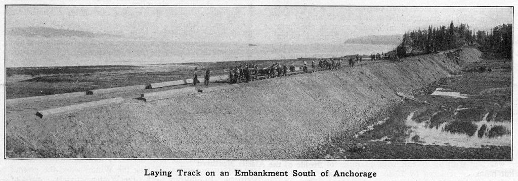
Laying Track on the Embankment South of Anchorage
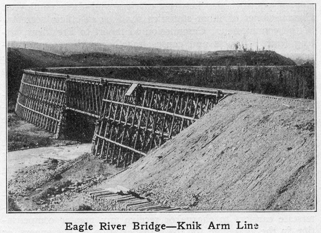
Eagle River Bridge - Knik Arm Line