Completing the Government Railroad in Alaska
Passengers and Freight Now Transported Between Seward
and Fairbanks A Distance of 467 Miles
Railway Age
April 1, 1922
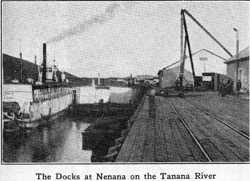
As concerns operation between the ends of its line, the Government Railroad in Alaska, now officially called the Alaska Railroad, is completed, the actual opening of the line between Seward on Resurrection Bay and Fairbanks in the interior, occurring on February 5, 1922. Previous to this time, trains had been operated over sections of the line as completed, and although transfer of passengers and freight is now effected through to Fairbanks, it is not carried out as yet by through rail connection except in the winter season. Actually Nenana on the Tanana river is the northern terminal of the road, passengers and freight being transferred at this point, ferried across the river and then carried to Fairbanks over a narrow gage line. In the winter the narrow gage tracks are laid on the ice in the river and the transfer from standard to narrow gage made at Nenana. Bids now being received by the government call for the construction and completion of a 700 ft. span structure across the Tanana river on or before March 1, 1923.
The completion of this structure with the necessary approaches, forms the main item in the budget for the fiscal year 1922 23. Other items of interest are a steel bridge at Spencer Glacier to replace a wooden structure now in use, the ballasting of about 50 miles of line in Broad Pass laid in the fall of 1921, and the widening to standard gage of about 56 miles of the narrow gage Tanana Valley Railroad to Fairbanks. When this i5 carried out, the Alaska Railroad will have a through, 467 mile standard gage line, with a total mileage, branches included, of about 539. Built through practically a wilderness, under trying conditions of weather and surroundings, aggravated numerous times by difficult physical obstacles, the railroad is an undertaking the completion of which is a credit to all concerned. Its construction recalls some of the more difficult of the pioneer railway building of the West with the addition further that it was carried on more than 2,000 miles from its base of supplies and in a country where there were few trails and roads. The authorization of the project was through an act of Congress passed on March 12, 1914, the cost being fixed at $35,000,000. Increasing prices for labor and materials during 1918 and 1919 soon developed the fact that the road could not be completed for that sum, and an additional authorization of $17,000,000 was made in 1919, making $52,000,000. This was still insufficient to complete the road and $4,000,000 more was requested. Based on a total expenditure of about $56,000,000, the Alaska Railroad will have cost, exclusive of equipment, etc., an average of about $78,000 per mile of line. With all facilities included, the cost is about $120,000 per mile of line. Articles descriptive of the progress of the railroad since its inception have appeared regularly in the Railway Age and are suggested as references in connection with this article.
Government Road Includes Two Existing Railroads
The line chosen for the government road includes two railroads initiated by private enterprise. It runs generally northward from Seward, a port open all the year, across the Kenai peninsula to Anchorage at the head of Cook Inlet, thence north along the general line of the Susitna river until. reaching the main part of the Alaskan range. In this section Mt. McKinley is but a short distance to the west, the boundaries of the reservation extending to the line of the railroad. The railroad passes over the Alaskan range through a section known as Broad Pass and emerges on the north onto the cañon lands of the Nenana river, and the valley lands of the Tanana river into the town of Nenana, 411 miles from Seward. From the bank of the river opposite Nenana, the line swings to the east, reaching Fairbanks at mile post 467. This is considered the northern terminus although the old Tanana Valley Railroad, of which more mention will be made later, extends on to Chatanika, a distance of 39 miles.
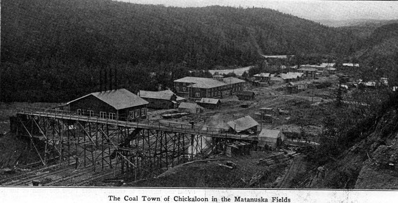
One of the several primary purposes of the government railroad was to tap and thus develop some of the great coal fields of Alaska as a source of fuel not only for the navy but for other shipping and mining facilities as well. It i interesting to know that Alaska contains practically the only satisfactory steaming coal on the Pacific coast as far south as Chile in South America. Another purpose was to transport inland the equipment and supplies needed to develop the mining and agricultural possibilities of the territory and to move out their raw and finished products. Coal, for instance, which formerly cost $18 a ton at Seward, was reduced to 9 to 10 a ton as soon as the line had reached the Matanuska coal fields, about 190 miles from Seward, and the first objective. The price of other products and supplies has been reduced since the completion of the line in a like or greater proportion with positive year around deliveries in contrast to the old closed season of about four to six months when nothing could be moved in or out.
The backbone of the southern end of the line was furnished through the acquisition by the government of the Alaska Northern Railway, formerly the Alaska Central. The original intention behind this road had been to tap the Matanuska coal fields but because of financial difficulties the work had never been completed. Seward was its deep water terminus and the old wharves of that road were rehabilitated by the government for use with the federal line. These wharves form the only berthage for vessels coming into this port. Resurrection Bay, although indented 20 miles and an excellent harbor so far as navigation is concerned, has the drawback of having from 50 to 150 fathoms of water, making it practically impossible for ships to lie at anchor.
Rehabilitating the Old Alaska Northern
Leaving Seward, the Alaska Northern had completed about 71 miles, over which it operated intermittently. Owing to financial troubles, it later reduced the mileage in operation to 35, using a light gasoline car to which a trailer was sometimes attached. During this period the roadbed was allowed to deteriorate and one of the first things which was done when the government took hold was to rebuild this line. New trestles and bridges, ties and rails were installed, while curves were straightened or eliminated and grades reduced and standardized. Approximately four and one half million dollars were expended in this work, which, up to Mile 71, formed the first undertaking of the Alaskan Engineering Commission. At about the same time a base was established on Ship Creek at the head of Cook Inlet. This was named Anchorage and became the headquarters from which all construction was controlled. All equipment, such as steam shovels, dredges, barges, locomotives, cars, etc., was landed at this base and much of it consisted of equipment brought up from Panama, where it was no longer needed. Work was started from this point toward the Matanuska coal fields and south toward Seward. About one year later a base was established at Nenana and construction started south from this point toward the lignite coal fields in that section of the country. The narrow gage Tanana Valley Railroad was acquired at about the same time and its rehabilitation commenced.
Leaving Seward the road
crosses two divides, reaching the summit of the first at Mile 12 with an
elevation of 700 ft., after which the
general
grade descends,
slightly rising again to the second summit at about Mile 45, elevation
1100 ft. The maximum grades in this section are 2.2 per cent compensated
for curvature,
with curves as sharp as 14 deg., of which, however, there are, in
proportion, only a few. Descending from the summit the line follows the drainage
of the Placer river and then enters the section where the heaviest
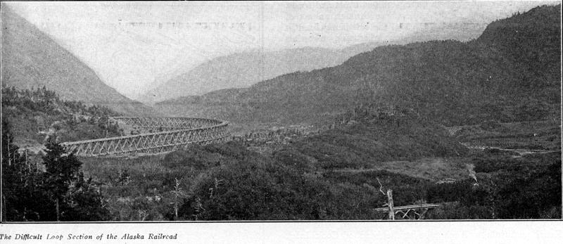
construction of the line occurred. This is the loop section of the
railroad. It contains
numerous tunnels and a large amount of trestle work built of Douglas
fir.
Indicative of
the class of work in this section is one trestle with a maximum height
of 106 ft. on a 14 deg. curve. From Mile 49 on to about Mile 61 is
the glacier
section
of the road, the line passing at varying distances from Bartlett
Glacier,
Spencer Glacier and Portage Glacier. It is also the section in which
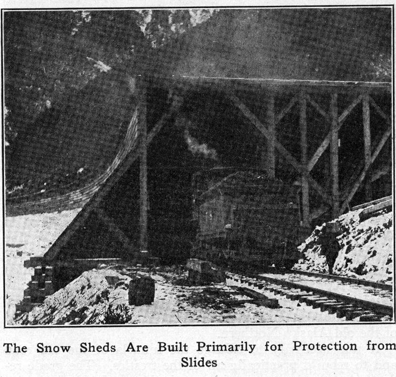
most of the trouble
from snow slides has occurred, practically all of the snow sheds
being located at points between roughly Mile 43 to 80, the latter point being
9 miles beyond
the end of the old Alaska Northern.
It was necessary to enlarge the tunnels of the old road and to rebuild
practically all of the trestles. The grade reduction and other work
also required some
heavy construction in the form of cuts and fills most of which was
carried out in hard rock that was difficult to handle. Being in the
glacier section
considerable trouble has been encountered in the tunnels through
seepage of water under pressure,
which, as soon as it strikes the air, freezes on the tunnel roof
and rapidly forms large heavy icicles causing some danger to train
operation.
It is
hoped to remedy this later by the installation of some kind of a
heating system.
The Problem of Snow Slides At Turnagain Arm
The waters of Cook Inlet branch out at their head to the south and north forming two bodies known respectively as Turnagain Arm and Knik Arm. This forms a small point of land, upon about the western point of which is located Anchorage at Mile 114, The head of Turnagain Arm strikes the railroad at about Mile 67, the line of the road following the shore line of Turnagain Arm into Anchorage, thence around the shore of Knik Arm on easy grades to about the head of the latter where it turns north a short distance reaching Matanuska on the river of the same name at Mile 152. In order to avoid several bad snow slides along Turnagain Arm, the railroad is carried out about 1/4 mile from the side hills on a trestle about one mile in length. A series of spur dikes were installed partly as a protective measure against ice and partly with the idea that the tidal action might eventually make a fill at this point. The tide in Turnagain Arm averages about 38 ft. from high to low and one can walk nine miles across the arm at low tide as far as from 18 to 20 miles from its head.
The coal fields are located approximately 40 miles from the main line of the railroad and are reached by a branch following the Matanuska river. This river overflows in certain sections, often cutting new channels and causing considerable trouble, in addition much of it runs between shale bluffs from 150 ft. to 250 ft. high and from 1,000 to 6,000 ft. apart. These are, for the most part, a partially disintegrated shale with a nearly vertical dip and are badly shattered. Through these points the line has been diverted away from the bluffs, since it was found that if they were cut into, immense quantities of this shale would have to be moved and even then there would always he danger of slides. As a consequence, the line has been thrown out into the stream in various places and in order to protect it from the action of the ice and water, sheer dams about 60 ft. long and filled with rock were built at various points during construction to deflect the river away from the track but later hard rock rip rap was found sufficient to protect the roadbed. The maximum grades used in the Matanuska coal field extension are 0.4 per cent against outbound loaded movement and 1.0 per cent against inbound empty movement. Thus for seven months of the year at least, it is possible to move out large quantities of coal in heavy tonnage trains to Anchorage for shipment out of Alaska.
Building North Along the Susitna River
Leaving Mile Post 152 where the Matanuska branch connects, the main line swings to the west and with a gradual curve to the north approaches the Susitna river and follows the river, more or less closely, for a distance of about 75 miles. The construction in places is heavy, the topography of the country requiring a large number of 100 and 120 ft. span bridges with approach trestles and considerable heavy cutting and filling. The construction of this section along the Susitna river was attacked at various points, the materials being moved in by water and by wagon road. From about Mile 233 the line leaves the flat lands adjacent to the river and follows the toe of the slope along the hills, holding very closely to the river edge. In one or two places the road passes over sections of the river bed. The grades are comparatively light with a maximum of one per cent in the heavy construction section.
At Mile 264. the river swings to the east, the railroad crossing it and continuing north into the Alaskan Range on a1.75 per cent grade compensated for curves. The Susitna bridge was described in detail in the Railway Age of July 16, 1921, page 103. It consists of one main span of a 504 ft. steel truss, spanning the entire river from bank to bank to avoid the menace to channel piers from the rush of the ice in the spring break up.
The Crossing at Hurricane Gulch
From Mile 264 the line ascends Indian river, a tributary of the Susitna, with increasingly heavy construction running into a section about 18 miles long, beginning at about Mile 284 and on which the cost of bridging was exceptionally heavy. The glacial streams in this section had eroded deep valleys which extend for many miles above the line crossing. The more spectacular of these crossings, known as Hurricane Gulch, is at Mile 284 where a deep gorge in the mountain side crosses the line, with a difference of elevation between the grade of the road and the bottom of the gorge of about 300 ft. The bridge used consists of a 384 ft. deck spandrel arch together with a number of steel girder approach spans giving a total length of about 920 ft. Construction was carried on entirely from the south end. A cable tramway of large capacity was first installed to serve the dual purpose of transporting bridge materials across to the bridge gangs and food and other supplies to a large grading camp on the north side. A large derrick was installed on the north side and as soon as construction had reached a point where it was practical, it was put into service. Materials including the steel bridge members were brought out upon the completed part of the structure where a locomotive crane picked them up and lowered them over the end of the cantilevered end of the partly completed bridge. The derrick on the north side then made fast and working together, the two cranes swung the heavy material to the far side where the derrick was able to place it in position.
Ascending to Broad Pass the construction was much lighter. Broad Pass is an opening through the Alaskan Range of unusual topography. It is 6 to 8 miles wide and from 20 to 25 miles long and dotted with numerous lakes. From Broad Pass the road drops down to the line of the Nenana river which it follows generally. This river flows in more or less of a canyon and is very crooked with cut banks nearly the entire distance. Through this section the tracks were kept away, as far as possible, from the action of the river. It was necessary to make a high level crossing of Riley Creek at Mile 347 on a steel viaduct. The crossing of the Nenana river at Mile 373 was made at an elevation providing only for a normal clearance over high water. In addition there were numerous other bridges and trestle work. Grades averaged between one per cent and 1.5 per cent as a maximum through this section which ran until the flat valley, lands of Tanana river were reached, the line being comparatively level into Nenana.
The Reconstruction of the Tanana Valley Railroad
The Tanana Valley Railroad which forms the northern section of the line is a narrow gage road 39.2 miles in length with terminii at Chatanika and Fairbanks. A line 32 miles long extends to Chatanika in the mining district from a junction point 7 miles from Fairbanks. One of the first acts of the Commission was the reconstruction of the Tanana Valley and the construction of about 49 miles of new line to connect up Fairbanks with Nenana. This was done in conjunction with the work of building south from Nenana and was for the purpose of reaching the lignite coal fields as quickly as possible so that cheap fuel might be obtainable for the mining industries. A sidelight on the fuel question prior to the completion of this work is the fact that the timber in the vicinity of the mining district had been cut and burned as fuel for a distance of 16 miles back. The price had reached $15 to $20 a cord.
In constructing the line from Nenana to Fairbanks the new section was laid to narrow gage as a temporary expedient. Grading, ballasting, bridges, ties, etc., were carried out on the basis of standard gage construction, the rail being laid to the gage required by the existing Tanana Valley equipment. The extension of the road running from the junction point to Chatanika was simply reconstructed as narrow gage and will be left and operated that way. With the closing up of the Government Railroad by the completion of the bridge across the Tanana river, the narrow gage to Fairbanks will be widened to standard although the section of line between that terminal and the junction point will be operated both as narrow and standard gage. The bridge across the river will be of the same general design as that across the Susitna river although naturally of a much longer span, 700 ft. in the clear as against 504 ft. at the Susitna crossing. The estimated cost of the structure including several miles of approach grades and trestles is given as $1,800,000 and one of the requirements of the construction is that it must be built between November 1, 1922, and March 1, 1923.
We are indebted to Col. Frederick Mears, chairman and chief engineer, and C. L. Mason, chief clerk, of the Alaskan Engineering Commission for the information contained in this article.
Freight Car Loading
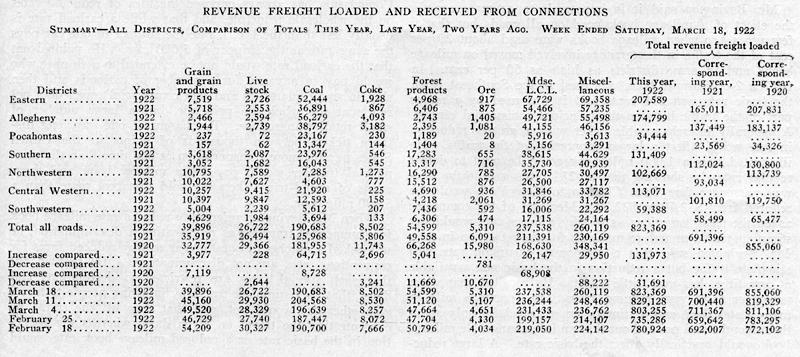
The number of cars loaded with revenue freight during the week ended March 18 showed a decrease of about 5,000 as compared with the week before, according to the weekly report compiled by the Car Service Division of the American Railway Association. The reduction was due to decreases in grain and grain products and also in coal in spite of the threatened strike, but the figures for the week show an increase of 132,000 as compared with the corresponding week of last year. The total was 823,369 as against 691,396 in 1921 and 855,060 in 1920. In basing estimates of traffic on the carloading figures, however, it is well to take into consideration the fact that the average loading per car this year is less than it was last year. For. January the average carload was 27.6 tons as compared with 30.1 in 1921.
As compared with last year increases in loading were shown as to all classes of commodities except ore, and increases were shown in all districts except the Southwestern. There was a gain as compared with last year of 65,000 cars in coal and of 30,000 in miscellaneous.
The summary for the week is given in the table at the bottom of this page.
The number of surplus freight cars showed another reduction during the week ended March 15 to 216,661, of which 79,803 were coal cars and 89,356 were box cars.
Photos accompanying the article:
The Difficult Loop Section of the Alaska Railroad
The Docks at Nenana on the Tanana River
A Sight No Longer As Familiar As It Was Some Twenty Years Ago
Completing One of the Trestles Along Turnagain Arm
The Coal Town of Chickaloon in the Matanuska Fields
The Snow Sheds Are Built Primarily for Protection from Slides
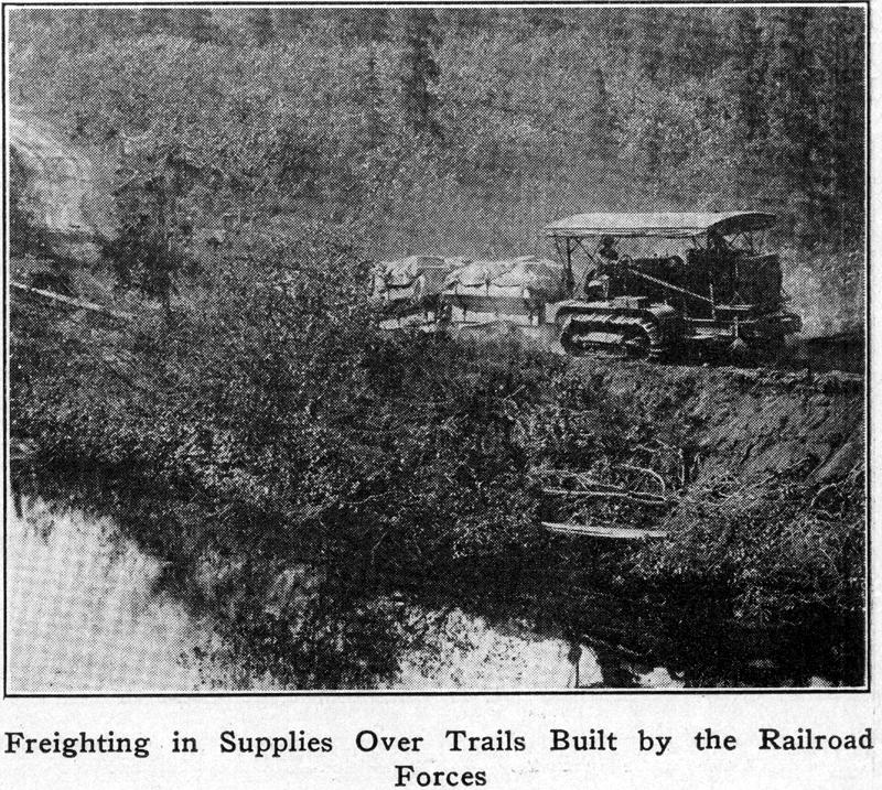
Freighting in Supplies Over Trails Built by the Railroad Forces